A 10 m Maize, Rice and Soybean Yield Dataset in Northeast China Enhances Food Security Strategies
Accurate crop yield mapping is essential for agricultural decision-making and optimizing resource allocation, playing a critical role in safeguarding national food security. Prof. SHI Wenjiao and her team at the Institute of Geographic Sciences and Natural Resources Research, Chinese Academy of Sciences, has developed a novel method to generate 10
m resolution yield maps for maize, rice, and soybean in Northeast China from 2016 to 2021. This high-accuracy dataset fills a key gap in multi-crop, long-term, high-resolution yield information. The work was published in the Springer Nature journal Scientific Data.
Maize, rice, and soybean are the main crops in Northeast China, a major grain-producing region. Precisely quantifying the annual yield of these crops are crucial for food production planning and agricultural management. However, existing crop yield datasets often lack coverage for multiple crops over large areas and long time periods at high resolutions. Traditional approaches mostly rely on downscaling statistical data, which fail to capture actual yield variations at the field scale. Moreover, conventional yield estimation techniques depend on numerous parameters, and involve high costs for field measurements, which limits their regional scalability - the above bottlenecks hinder the advancement of precision agriculture and the formulation of effective food security policies.
To address these challenges, under the guidance of Prof. SHI Wenjiao TENG Fei and the team developed a new estimation approach that obviates the reliance on field-measured yield data for model training. Based on the Vegetation Photosynthesis Model (VPM) and using Sentinel-2 satellite imagery, meteorological data, and statistical information, they innovatively integrated dynamic observation indices and comprehensive conversion coefficients. This method enabled them to produce the first 10 m resolution yield datasets for maize, rice, and soybean across Northeast China for 2016-2021.
The proposed method delivers substantial enhancements in both efficiency and accuracy. The team validated the dataset using field observations and official statistics, and comparing it with traditional yield estimation methods. The results showed that the mean relative errors (MRE) for maize, rice, and soybean were 12%, 12%, and 14%, respectively, indicating high reliability and consistency. Compared with Global Gridded Crop yield datasets (GGCP), the overall accuracy for the three crops improved by 32%.
This dataset provides scientific data and methodological support for research on spatio-temporal analysis and simulation of agricultural systems, as well as for agricultural production management and food security policy formulation.
Reference:
Teng, F., Wang, M., Shi, W. et al. A 10 m maize, rice and soybean yield dataset from 2016 to 2021 in Northeast China. Sci Data 13, 344 (2026). https://doi.org/10.1038/s41597-026-06719-0.
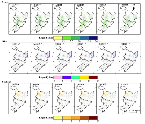
A 10 m resolution yield distribution map of maize, rice, and soybean in Northeast China for 2016-2021, generated using an improved VPM method. (Image by Prof. SHI’s team)
Download attachment:
