Reconstructing missing Remote Sensing(RS) information caused by poor atmospheric conditions and defective sensors may improve the availability of RS data. Prof. YANG Xiaomei’s team at Institute of Geographic Sciences and Natural Resources Research of Chinese Academy of Sciences found that sparse dictionary learning is beneficial for clouds removal from high-spatial resolution RS images. Further studies showed that multiscale sparse representation can well recover missing surface information for RS data, yielding consistent textures and structures with surrounding information. These works were published in Sensors and Remote Sensing Letters.
Many studies have been dedicated to coping with the inverse problem of missing RS information reconstruction. However, some approaches cannot work when suffering from significant spectral difference, severe overlapping of missing information, or rapid land-cover change. Moreover, most existing methods based on spatial complementation will introduce artifacts and discard details.
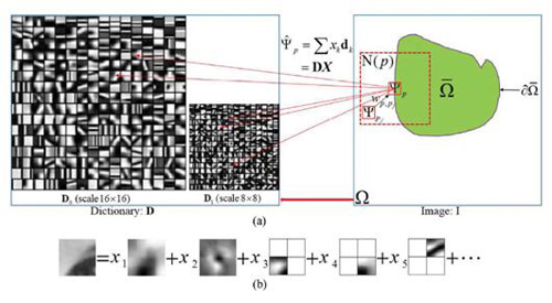
Image features usually tend to repeat themselves both within the same scale and across different scales. Meanwhile, different features prefer different scales for optimal representation. Inspired by the idea of exemplar-based inpainting and latest progress on sparse representation, researchers recovered missing RS data via multiscale adaptive sparse representation.
Their main contributions lie in: 1) scale adaptive patch inpainting; and 2) introduction of adaptive neighborhood consistency into the optimization model of patch inpainting.
They trained multiscale feature dictionaries using different sizes of exemplars from the known image region, and utilized them to infer missing information patch-by-patch via sparse representation afterwards. Structure sparsity was incorporated to encourage filling-in of missing patch on image structure. Neighboring information was also employed to restrain the appearance of estimated patch, to yield semantically consistent inpainting result.
They performed experiments on cloud removal, gaps filling and quantitative products reconstruction, and results demonstrated the effectiveness of proposed method.
These works were supported by the National Key Research and Development Program of China and the National Natural Science Foundation of China.
 |
|
Illustration of multiscale sparse representation: (a) multiscale adaptive patch inpainting; (b) possible representation of a patch under multiscale dictionary (Image by YANG Xiaomei) |
Reference:
F. Meng, X. Yang, C. Zhou, et al. (2018),Multiscale Adaptive Reconstruction of Missing Information for Remotely Sensed Data Using Sparse Representation. Remote Sensing Letters, 2018, 9(5): 457-466.
F. Meng, X. Yang, C. Zhou and Z. Li, (2017), A sparse dictionary learning-based adaptive patch inpainting method for thick clouds removal from high-spatial resolution remote sensing imagery. Sensors, 17(9), 2130.
