During vegetation restoration, guideline that can help to decide where to plant tree, grass or shrub, are very important to lead an effective ecological restoration. Taking the Loess Plateau of China as an example, Dr. CHEN Pengfei at Institute of Geographic Sciences and Natural Resources Research of Chinese Academy of Sciences, and his team proposed a new regionalization method and corresponding regionalization scheme to inform the proper selection of vegetation types for particular locations on Loess Plateau during ecological restoration. This work was published in RemoteSensing.
When considering how to select the vegetation type for restoration in a given location, existing studies identified vegetation restoration zones by theoretically matching plant characteristics to local climate and soil properties that existed before the vegetation restoration projects began, based on simulation model or expert experience.
“In fact, when the vegetation is planted in a given location, the situation may be different from the simulation condition because of the error of the model or the special regional microclimate. Unlike the situation that existed when the ecological restoration projects had just started, numerous restoration projects have been conducted for many years, such as the Grain for Green Program (GTGP) in China,” said Dr. CHEN.
“If the actual growing status of vegetation during the restoration project can be investigated and used as a reference in developing a better plan for vegetation recovery, this should have considerable potential to lead to successful and efficient ecological restoration in the future,” he added.
Based on above consideration, collecting remote sensing data covering the periods before and after the implementation of the GTGP (the 1980s and 2001–2013), along with soil, meteorological, and topographic data, researchers calculated the net primary production (NPP) values for 2001–2013 using the Carnegie-Ames-Stanford Approach (CASA) model.
First, Locations representing the native vegetation and the restored vegetation were recognized using long term maps of vegetation cover. Then, for the restored vegetation area, the places suitable for planting the covered vegetation type were recognized by comparing the NPP value of the corresponding vegetation type in the native vegetation area to the NPP value in the site under consideration.
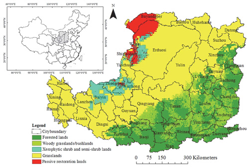
They combined meteorological, soil, topographic data and the vegetation growth status in each parcel of land in the restored vegetation area, divided the Loess Plateau into five different restoration zones, which are suitable for planting tree, woody grass/bush, grass, xerophytic shrub and semi-shrub, and making passive restoration respectively.
In addition, the proposed regionalization scheme was validated using independent data and by comparing it with existing Chinese eco-geographical regionalization scheme and other small scale studies.
The result showed the new scheme had good accuracy and has great potential to be used in the Loess Plateau to help guide vegetation restoration activities.
The study was done in collaboration with Ottawa Research and Development Centre, Agriculture and Agri-Food Canada.
The work was supported by the Science and Technology Basic Research Program of China, the National Research and Development Plan of China, and the Innovation Project of the State Key Laboratory of Resources and Environmental Information System of China.
 |
|
Figure: New regionalization scheme for helping select the proper vegetation type during vegetation restoration on the Loess Plateau. (Image by Dr. CHEN Pengfei) |
