Ground observation is able to obtain highly accurate data with high temporal resolution at observation points, but these observation points are too sparse to satisfy some application requirements.
Satellite remote-sensing and system models can frequently supply spatially continuous information about the Earth’s surface, which is impossible from ground-based investigations, but remote sensing description and system model simulation are not able to directly obtain process parameters.
The most effective method for Earth surface modelling entails the integration of satellite observations or system models with ground observations. However, the full integration was ignored in most of the methods.
For finding a solution for this problem, prof. YUE Tianxiang and his team, Institute of Geographic Sciences and Natural Resources Research (IGSNRR), Chinese Academy of Sciences, suggest an alternative method, high accuracy surface modeling (HASM), which takes global approximate information (e.g., remote sensing images or model simulation results) as its driving field and local accurate information (e.g., ground observation data and/or sampling data) as its optimum control constraints.
HASM completes its operation when its output satisfies the iteration stopping criterion which is determined by application requirement for accuracy. A Fundamental Theorem of Earth’s Surface Modelling (FTESM) is abstracted on the basis of applying HASM to simulating surfaces of elevation, soil properties, changes of ecosystem services, and driving forces of the changes on multi-scales for about 20 years.
FTESM is described as “an Earth’s surface system or a component surface of the Earth’s surface environment can be simulated with HASM when its spatial resolution is fine enough, which is uniquely defined by both extrinsic and intrinsic invariants of the surface”. From FTESM, seven corollaries have been deduced, corresponding to interpolation, upsaling, downscaling, data fusion and data assimilation respectively.
The related results have been published in the journal of Environmental Earth Sciences (TianXiang Yue, Yu Liu, MingWei Zhao, ZhengPing Du, Na Zhao.A fundamental theorem of Earth’s surface modeling, Environmental Earth Sciences, 2016, 75:751 DOI 10.1007/s12665-016-5310-5). l Interpolation of local information with extracted global information makes the accuracy of the surface of mean annual precipitation increased by 6%.
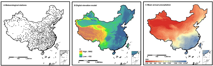
a) Spatial distribution of the meteorological stations with location information in China, b) Digital elevation model of China, c) Surface of mean annual precipitation during the period from 1961 to 2010 in China, generated by HASM(Image by YUE Tianxiang)
l HASM data fusion can make the mean relative error of surfaces of carbon stocks reduced by at least 53%, comparing with satellite-observation-based approach and Kriging interpolation.
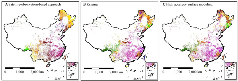
Fig.2. Surfaces of carbon stocks created by different methods: a) created bysatellite-observation-based approach, b) created by Kriging interpolation and c) created by HASM data fusion(Image by YUE Tianxiang)
l The data assimilation made the mean absolute error of GEOS-Chem model decreased by 16%
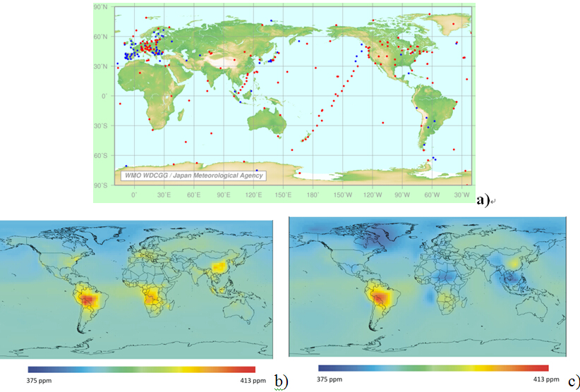
Fig.3. a) Distribution of the fixed stations that contribute data to the WDCGG (http://ds.data.jma.go.jp/gmd/wdcgg), b) surfaces of CO2 concentrations generated by GEOS-Chem model, c) surfaces of CO2 concentrations created by HASM(Image by YUE Tianxiang) 