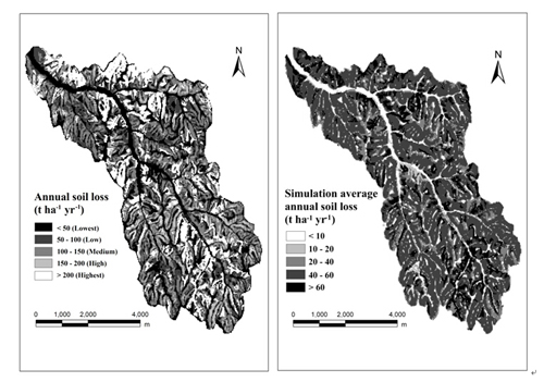
Due to fragmentized terrain and physiognomy of typical loess landform, long-term anthropogenic influences, and inherent vulnerability, soil erosion is a serious problem in the Loess Plateau of China. There is a critical need to assess soil erosion and spatial distribution for achieving sustainable land use and comprehensive soil conservation management. The appropriate land-management measures at watershed scale should be discussed by researchers, decision-makers, and planners to control soil erosion and achieve sustainable development in the Loess Plateau of China.
Dr. TANG Qing, Prof. XU Yong from Institute of Geographic Sciences and Natural Resources Research, Chinese Academy of Sciences, Prof. BENNETT Sean J. from State University of New York at Buffalo, and Dr. LI Yang from China Center for Modernization Research, Chinese Academy of Sciences, used an integrated RUSLE-GIS model to estimate soil loss and its spatial distribution for the Yangou watershed within the Chinese Loess Plateau, analyzed the benefits of soil conservation of different land use types, and discussed future measures for soil conservation planning.
They found that silt-covered land and terrace have high benefits of soil conservation, indicating that building check dam, producing silt-covered land for farming, and converting sloped farmland to terrace are effective ways to control soil erosion in the Yangou watershed. Furthermore, increasing vegetation coverage on lower coverage grassland, especially on the slopes with gradients >25°, and eliminating human disturbance in barren areas are feasible and effective measures for soil conservation planning.
This study reveals that the integrated RUSLE-GIS model can evaluate and map soil erosion quantitatively and spatially at watershed scale in the Loess Plateau of China. The findings suggest strategies for coping with future soil conservation planning and provide valuable references for future assessments both in the Loess Plateau of China and elsewhere.
The related results have been published in the journal of Environmental Earth Sciences (Tang, Q., Xu, Y., Bennett, S. J., Li, Y Assessment of soil erosion using RUSLE and GIS: a case study of the Yangou watershed in the Loess Plateau, China Environmental Earth Sciences, DOI 10.1007/s12665-014-3523-z ).
This research was supported by the National Natural Science Foundation of China (Grant No. 41301121), the Key Project for the Strategic Science Plan in IGSNRR, CAS (Grant No. 2012ZD006), and the National Natural Science Foundation of China (Grant No. 41171449).
 |
|
Spatial distribution map of average annual soil loss and simulation average annual soil loss in the Yangou watershed(Imaged by TANG Qing) |
