Terrestrial Water and Soil Processes Laboratory
|
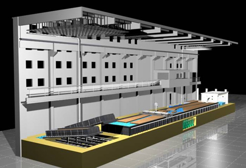
Water and Soil Processes Experiment Hall | |
|
| |
|
|
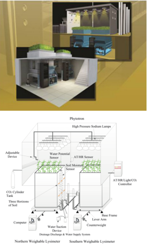
Name: Transformation Dynamical Processes Experimental Device among Precipitation, Vegetation water, Surface water, Soil water, and Groundwater Model:Self-development Introduction: The device is a complex equipment to study the water process among the five different types of water. It is hermetically sealed in the house (7 m long, 5 m wide, and 7.5 m high) and consists of two sections joined together, 7.5 m above ground and 3 m underground. The underground part consists of two large weighing lysimeters, and is equipped with 14 groups of measuring devices for soil water potential, temperature, conductivity, moisture content and other parameters and soil aqueous solution extractors in the vertical direction. The aboveground part can control elements such as light, temperature, humidity, carbon dioxide and so on. The devices can be used to conduct the mutual transformation experiment among precipitation, surface water, groundwater, soil water, and plant water indoors. |
|
|
Name: River Simulation System Model:Self-development Introduction: The river simulation system is 38 m long, 6 m wide, and 1 m high. It is designed with water and sediment supply system, crustal lifting simulation device, multi-functional automatic control measuring bridge, tail gate, artificial intelligence modeling system, erosion datum control system, model river testing and sampling system, topographic survey system, etc. The borders are made of concrete and sealed with the ground to prevent water leaching from them. The crustal lifting simulation system is installed in the middle. It is composed of 12 square steel blocks (2 × 2 m). Each block is supported by four stainless steel-threaded rods, which can be adjusted up and down. The 12 square blocks can be automatically motioned to form 82 types of crustal shape. The rate of motion is as slow as 30–70 mm/day. The multi-function automatic measuring bridge is placed above the system to move from the upstream to the downstream. It can automatically measure water flow, water depth, and cross-section of the modeled river. At the end, there is a big tank where the recycled water can be pumped to the upstream.
|
|
|
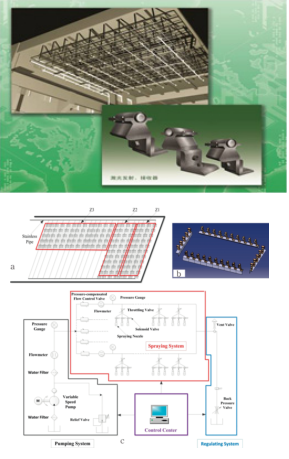
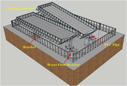
Name: Artificial Rainfall Simulation System Model:Self-development Introduction: The artificial rainfall system is set up at the height of 18 m in the hall. It includes three rainfall zones. The total area is 370 m2. The rainfall can be achieved in each separate zone or in all three zones at the same time. The system consists of variable speed pumps, stainless pipes, control center, laser rainfall monitor, and sets of solenoid valves and spraying nozzles. Every set of solenoid valves and spraying includes three valves and three nozzles which can be combined to produce 12–300 mm/h rain and mobile storm. A pressure-compensated flow control valve and a pressure gauge are located at the same altitude of the nozzle allowing a precise control of water pressure and consequently the constancy of rain kinetic energy. The calibration tests showed that the uniformity of the rainfall intensities was greater than 85%. Laser rainfall intensity monitor is installed at the mid-height of nozzles. It is composed of an array of laser transmitters and receivers. It achieves the rain non-touch measurement using orthogonally multiplexed laser beams according to the light attenuation law. The measurement error is less than 2%. |
|
|
Name: Runoff and Soil Erosion Flume Model:Self-development Introduction: Two flumes with variable slope, the length, width and height of which are 10 m, 3 m and 0.8 m, and the slope range is 0-35 degrees, which can be continuously adjusted. It is equipped with automatic measuring and collecting devices for water and sediment. The flume body is made of channel steel welded frame, and the rivets cover 8 mm thick steel plate with high-strength structure. There are 75-100 cm high steel frame glass retaining walls on both sides and upstream of the tank, so as to observe the infiltration in the tank during rainfall and the activities of subsurface runoff on the slope surface. This equipment can be used to study the effects of rainfall process, slope material composition, different underlying surfaces, and slope control measures on runoff and infiltration, and sediment yield. |
|
|
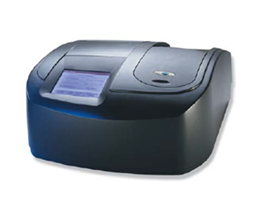
Name: Multi-parameter Water Quality Analyzer Model: HACHDR5000 Introduction: HACH DR5000 series water quality analysis laboratories use visible light of a certain frequency to irradiate the analyzed organic substances, causing the transition of valence electrons in molecules, which will be selectively absorbed. In the range of visible light, for a specific wavelength, the degree of absorption is proportional to the concentration of the component in the sample. Quantitative analysis can be carried out according to the comparison between the absorption and the standard sample with the concentration, and the water sample can be measured in visible light. It is used to determine the concentration of organic substances in water samples, such as chemical oxygen demand, total nitrogen, total phosphorus, TOC, ammonia nitrogen, etc. It can be used to determine the concentrations of inorganic substances such as nitrate, potassium ion, aluminum, iron, lead, and manganese in water samples. |
|
|
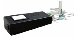
Name: Liquid Isotope Analyzer Model: LGR DLT-100 Introduction: The liquid water isotope analyzer can accurately measure the ratio of18O/16O and D/H isotopes in liquid water samples, with accuracy of 0.1‰ and 0.5‰ respectively. The optional automatic injector can ensure long-term monitoring and research of the instrument without manual intervention. Due to its ruggedness and portability in the field, the instrument can be widely used in hydrology, analytical science and biological science research.
|
|
|
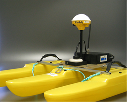
Name: Acoustic Doppler Flow Meter Model: River Surveyor S5 Introduction: There are multiple ultrasonic transducers (probes) that emit ultrasonic waves in multiple directions at the same time, because there are some suspended particles in the natural water, and these suspended particles at different distances will reflect some of the acoustic waves propagating to the location back to the transmitting instrument. The instrument can analyze the reflected signals from different distances. If these suspended particles are approaching the instrument, the reflected frequency will be higher than the transmission frequency, and if they are far away, they will be lower than the transmission frequency. The instrument can calculate the water flow velocity by substituting the small difference of frequency into the Doppler frequency shift equation. It can accurately measure the velocity of rivers, open channels, etc., and simultaneously measure the relative velocity, ship speed, water depth of the water body, as well as the ship's navigation track, which can output a complete section profile of the waterway, section area, and three-dimensional velocity of each point. |
|
|
Name: Ground Penetrating Radar Model: Pulse EKKO PRO Introduction: Commonly known as "underground B-mode ultrasound", it uses electromagnetic waves in the form of broadband short pulses to send from the ground to the ground through a probe, return to the ground after being reflected by the underground stratum or the target, and be received by another probe. The location and burial depth of the underground stratum or the target can be judged through the received information and images. It can be applied to detect buried objects at different depths underground.
|
|
|
Name: High Purity Germanium Gamma Spectrometer Model: GMX60 Introduction: According to the radioactive release characteristics and half-life of radioactive elements, the rapid acquisition of surface evolution processes and characteristics can be realized by measuring the changes of radioactive content in the field soil or indoor and outdoor simulated rainfall, combining with the measurement of background values and using relevant models. The instrument can be used to analyze the geomorphic evolution and scale of different landscapes such as forests, grasslands and farmland ecosystems, and can also study the geomorphic evolution and development laws caused by soil erosion through rainfall simulation indoors. |
|
|
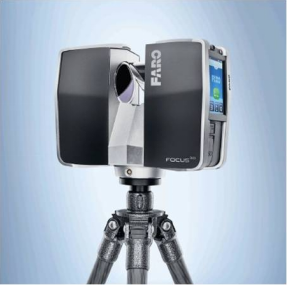
Name: 3D Laser Scanner Model: FOCUS 3D 120 Introduction: Focus 3D works by shooting an infrared laser beam into the center of the rotating optical mirror. The optical mirror will cause deviation of the laser in the direction of vertical rotation around the scanning environment; The scattered light from the surrounding objects is then reflected back to the scanner. Focus 3D uses phase offset technology to measure distance. Then, the X, Y, Z coordinates of each point are calculated by measuring the mirror rotation and horizontal rotation of Focus 3D with an angle encoder. The laser scan is recorded on the removable SD memory card.It can be widely applied in indoor and outdoor scanning. |
|
|
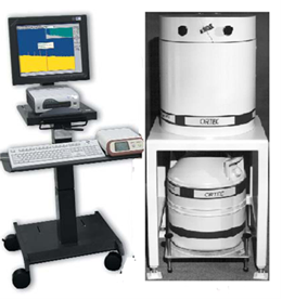
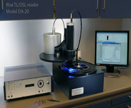
Name: Automatic Luminescence Dating Instrument Model: DA-20C/D Introduction: Ris TL/OSL-DA-20C/D automatic luminescence dating instrument complete set of equipment includes: TL/OSL reader; Electronic equipment and detector and control equipment; Beta irradiator accessories; Infrared/Blu ray OSL accessories; Heating system; Control and function software; Special application software; Filter; 90Sr/90Y radioactive source (1.48 GBq) and supporting computer terminal, etc. The instrument can be used for dating Quaternary sediments, dating archaeological samples, research on the basic characteristics of thermoluminescence and photoluminescence of minerals, physical research on photoluminescence and thermoluminescence of various crystals, research and measurement of luminescent radiometric materials, identification of the authenticity of ancient objects, and research on radioactive environment. |
|
|
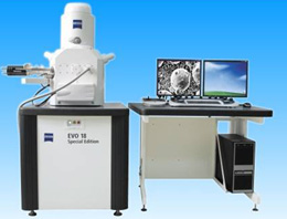
Name: ZEISS Scanning Electron Microscope Model: EVO18 Introduction: The scanning electron microscope uses the electron beam as the light source. The electron beam passes through the three-stage electromagnetic lens under the effect of the accelerating voltage, and does raster scanning on the surface of the sample under the effect of the scanning coil on the upper part of the final lens, to generate various physical information related to the properties of the sample (such as secondary electrons), and then collects and processes them, so as to obtain the scanning electron image characterizing the morphology of the sample. SEM is widely used in the inspection and research of metal materials (steel, metallurgy, non-ferrous, machining) and non-metallic materials (chemistry, chemical industry, petroleum, geology and mineralogy, rubber, textile, cement, glass fiber). In the fields of material science, metal materials, ceramic materials, semiconductor materials, chemical materials, etc., the micro morphology, structure and composition of materials are analyzed. Morphological and structural observation of various materials, material fracture analysis and failure analysis, material real-time micro area composition analysis, element quantitative and qualitative composition analysis, rapid multi-element plain scanning and line scanning distribution measurement, crystal/grain phase identification, grain size and shape analysis, crystal and grain orientation measurement.
|
|
|
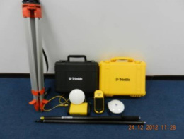
Name: Rear Differential High-precision GPS Model: GEO 6000XH Introduction: Real time accuracy of RTK or VRS network measurement with external antenna (baseline distance less than 30 km): plane accuracy 1 cm+1 ppm, elevation accuracy 1.5 cm+2 ppm; Real time accuracy of RTK or VRS network measurement with built-in antenna (baseline distance less than 30 km): plane accuracy 2.5 cm+1.2 ppm, elevation accuracy 4 cm+2 ppm. |
|
|
Name: High Speed Freezing Centrifuge Model: CR21GIII Introduction: Centrifuge is an instrument for separating, concentrating and purifying suspensions and emulsions according to an outward centrifugal force when particles are rotating at high speed and moving in a uniform circle. The high-speed freezing centrifuge drives the rotor to rotate at a high speed through the driving part, so that the sample in the rotor is subjected to a large centrifugal force field; According to the needs of the experiment, the equipment can also maintain the temperature of the centrifugal chamber and the sample within the set range by means of compressor refrigeration, so as to protect the sample and equipment. Maximum speed: 21000 rpm, maximum centrifugal force: 50300 Xg. The relationship among soil suction, bulk density and weight moisture content was obtained by centrifugation.
|
|
|
Name: X-ray Diffractometer Model: XRD-7000 Introduction: Each material is composed of different atoms, with different spacing d values between atoms. After X-ray irradiation on the sample surface, the incidence angle meets n λ= 2dsin θ. The X-ray diffraction peak will be generated when the temperature is 0, and different materials have their own characteristic X-ray diffraction peak. Therefore, when the X-ray is rotated and scanned at a certain angle on the surface of the sample, the phase composition of the sample can be judged through the data interpretation of the spectrum obtained on the detector. It can be used to detect the material phase structure, and analyze the source and sedimentation law of sediment by measuring the clay minerals of sedimentary species. |
|
|
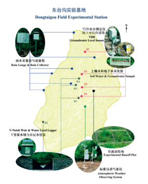
Name: Dongtaigou Field Experimental Station Introduction: Dongtaigou Field Experimental Station is designed for the long-term observation of water cycle processes impacted by soil and water conservation projects. Dongtaigou catchment is a part of the Baihe watershed in the northern part of Yanshan Mountain in Northern China (40°45′N, 116°37′E). A detailed water cycle experiment has been initiated in a 0.64 km2research catchment. The slopes in the catchment are steep, with an average of 30° and altitude of 290–530 m. The south-north oriented catchment is in the temperate zone and a semi-humid monsoon climate, with average annual temperature of 9–9.5°C and precipitation of 511 mm. The precipitation occurs mainly in June–September with the type of storms which take up 81.2% of the total amount of the year. The bedrock of the region is mainly andesite, covered with meager cinnamomic soil. Constrained by the natural conditions, the catchment has a single and simple vegetation with the coverage of 70%. It is covered with perennial shrubs and herbs such as twigs of the chaste tree, axillaries, and apricot and a small amount of other economic trees such as hawthorn and pear. Detailed observations of surface and subsurface water dynamics have been made at the catchment. |
|
|
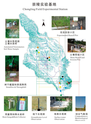
Name: Chongling Field Experimental Station Introduction: It is located in Chongling catchment in Yixian County, Hebei province of China (115°21′E, 39°23′N). Chongling catchment is in the north of Taihang mountainous region, which is a tributary of north Yishui River. It covers a total area of approximately 6 km2, with a length of 4.4 km and a width of 1.5 km at an altitude of approximately 70–300 m above the sea level. The research catchment was chosen for studying on hydrological process affected by typical vegetation in North China. The area has a temperate climate with average annual air temperature of 11.6°C. There are dry season (from September to May) and rainy season (from June to August). The annual precipitation ranges from 217.0 to 1004.3mm, on an average of 641.2 mm. The mean annual evaporation is 1906 mm by E601B Evaporator. The soil type in the catchment is predominantly sandy loam soil and loess, which is mainly cumulated in the valley, with depth of 1–2 m. The vegetation coverage in this area is diversified. The catchment drains in a southeasterly direction and the contributing hillslopes are each divided into five gully channels from east to west of the watershed, that is, Yangshugou, Wanmulingou, Yanghuaigou, Langweibagou, and Huyaogou. There are also two little gully channels (Chenglingou and Langyaogou) in the southeast of the watershed. |
Download attachment: