Exploring of the Canyon of Daduhe River2
“Noah's ark”—The Dawa Mountain
LI Mingsen, YANG Yichou
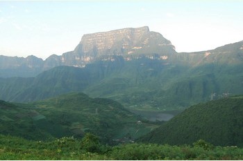 The Dawa Mountain, which is at an altitude of 3,236 meters, 170 meters higher than the adjacent Jinding scenic spot of Emei Mountain, the famous Buddhist sacred land, extends along the northwest side of the canyon of the Daduhe River. The height between its peak and the bottom of Canyon at the South Foot is about 2600m, much deeper than one of the Three Gorges of Yangtze River in China as well as the Grand Canyon of the Colorado in North America.
The Dawa Mountain takes the shape of a flat surface table, the crown face covers an area of 1.6 square kilometers, and it is formed by basalt that piles on underlying Permian limestone layers. The basalt, whose vertical joints is eroded and changed by external force, stands isolated just like a table. This is the featured geopotential of the Dawa Mountain. Furthermore, the Dawa Mountain is a table mountain formed by the raised massif caused by crustal fault. Since it enclosed by three sides of precipitous cliffs that are like three grand tiles, the mountain is named as‘ the Dawa Mountain’(‘Grand Tile’ in literal). It is formed by overflowing magma basalt, erupted by plate faulting 200 millions years ago in western Sichuan province.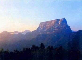
Surrounded by rhododendrons, spruce forest and rape pollens, the Dawa Mountain deserves the title of “Noah's ark”, that is given by foreign scholars, and its table shape with distinctive edges and corners standing up into flying fogs and clouds, showing alarming unique magic and magnificent scenery.
