Yarlung Zangbo River
 The Yarlung Zangbo River, an international water system, is located at the Tibet Autonomous Region and a river with the highest altitude in the world. The total length of the Yarlung Zangbo River in China is 2,057 kilometers, ranking the 5th longest river among the famous rivers of China. It has a drainage area of 240,480 square kilometers, and ranks the 6th largest river in China. Its annual runoff volume to foreign country is 140 billion m3, ranking the 3rd largest in China, just next to the Yangtze River and the Pearl River.
The Yarlung Zangbo River, which finds its source on the Gyaimanezong Glacier in Zongba County in the northern foothills of the Himalayas, belongs to the water system of the Indian Ocean. The Yarlung Zangbo River flows from west to east across the southern section of the Tibet Plateau. It first runs across Mailing, then turns to north and east before sharply flowing south toward and then flowing into India. After it flows into India, its name is changed to the Brahumaputra River, which later meets with the Ganges River before joining the Indian Ocean from the Bay of Bengal.
The total drop height of the Yarlung Zangbo River is over 5,400 meters in China, so it is the most precipitous river in China. The upper reaches are from the river source to Lizi, with a length of 268 kilometers. The river valley of this segment is broad and even, the river water is limpid and many lakes are located at this segment. Various grasses on the both sides of the valley are lush and they are colorful and sightly during the flowering season. Though sparsely populated, it is the Land of Peach Blossoms for wild animals. The wild yaks, Tibetan antelopes, bharals and other animals can be seen everywhere. In addition, there are some precious animals, such as the Tibetan wild donkeys, tableland foxes, snow leopards and marmots etc. Some birds of rare species for viewing and admiring also inhabit in the valley of the Maquan River.
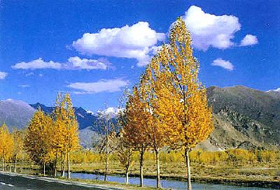
The middle reaches of the Yarlung Zangbo River are from Lizi, through the Lazi, Rikaze, Qushui and Zedang, to Mailing County, with a length of 1,340 kilometers. The main distributaries of the Yarlung Zangbo River are flowing into the trunk river in the middle reaches. This segment can provide advantageous conditions for the plateau shipment due to its abundant water quantity, broad river surface and deep water. The rubber boats and wood boats can boat from the western Lazi to the eastern Zedang. This navigation segment is about 400 kilometers in length and it is the highest river segment of navigation in the world. With plenty of sunlight, good irrigation conditions and sparse population, it is the richest and most important agricultural area known as the Grain Barn of Tibet. The main crops include the highland barley, potato and wheat.
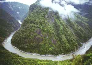
The lower reaches are from Paixiang of Mailing County to the Baxika, with a length of 496 kilometers. The vertical drop height from the Namjagabrwa Peak to the water surface of the Yarlung Zangbo River is 7,100 meters, so it is reputed as the deepest Grand Canyon (i.e. the Grand Canyon of the Yarlung Zangbo River) in the world. The river is narrow here, the reefs are everywhere on the riverbed, the river water is rapidly rushing and the waves are high. The spectacular downstream of the Yarlung Zangbo River has been the paradise of explorers all through the ages.
Source: http://www.chinaculture.org
